(Geology)
Geology Article: Little-known
Quake, Tsunami Hazards Lurk Offshore of Southern California
Reference and link to article: http://news.agu.org/press-release/little-known-quake-tsunami-hazards-lurk-offshore-of-southern-california/
|
Geology terms used in article and explanations of connections
Earthquakes: A sudden shaking of the ground in a violent manner caused by movements in the Earth’s crust Tsunamis: A long high sea wave caused by an earthquake Faults: A crack in the Earth along which slippage has occurred Transpression: A combination of compression and translation |
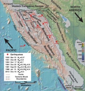
California Borderland and locations of earthquakes greater than magnitude 5.5. Arrows indicate relative motion of plates for the Pacific-North American fault boundary
|
Summary and Opinion of Article
The article is about research into the fault-riddled undersea landscape off of Southern California and Northern Baja California. Research has revealed potential for tectonic interactions to produce 7.9 to 8.0 magnitude earthquakes. Studies suggest that these vertical fault zones have displaced the seafloor in the past and therefore can send tsunamis towards the nearby coast of Los Angeles and San Diego. Geologist Mark Legg refers to the interaction as a complicated logjam. This logjam is composed of blocks of Earth’s crust caught in between the North American tectonic plate and the Pacific plate. The California Continental Borderland is the name given to this region which includes the Channel Islands.
The article mentions bathymetry which are seafloor depth measurements which Legg used along with digital seismic data from earthquakes to take a closer look at the structure of some faults in the Borderland. They searched for signs indicative of how much the faults have slipped over time and whether this caused some of the seafloor to thrust upwards. What was found was similar of what is seen along the San Andreas Fault. The Ferrelo Fault zone showed thrust faulting: an upward movement of one side of the fault causing the blocks to be compressed as well as slide past one another horizontally (Transpression as Legg describes).
I believe that further studies should be placed on a level of extreme importance regarding this Borderland region due to the implications that is poses. It is one of the least well mapped and understood regions and if research suggests that catastrophic earthquakes can be produced from this, then the States potentially affected should turn to studying how to divert such damage.
